About SkyHound
From deer recovery to agriculture and construction monitoring, SkyHound is your partner for aerial surveying solutions.
Aerial Intelligence, On Demand
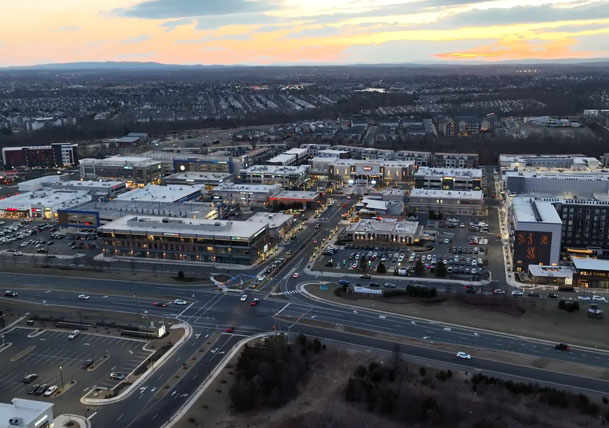
SkyHound delivers fast, accurate drone-based data for construction, agriculture, and land management projects. Our high-resolution mapping, LiDAR, and thermal imaging services provide the insights you need to make informed decisions and stay ahead of schedule.
Precision Meets Efficiency
With advanced drone technology and expert pilots, we collect site data up to 10x faster than traditional methods—without compromising accuracy. That means fewer delays, lower costs, and smarter project planning.
Built for Complex Environments
Whether you’re surveying rough terrain, managing a remote job site, or analyzing large crop fields, SkyHound operates safely and effectively—even in airspace-restricted zones. We handle the logistics, permitting, and compliance, so you don’t have to.
100+
Deer recoveries completed
30K
Acres mapped
10K+
Acres flow for agriculture clients
industries we serve
agriculture

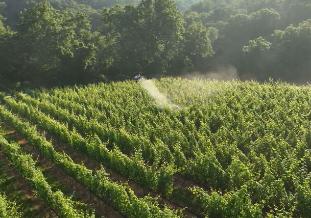
From drone-powered crop spraying to large-scale property mapping, our advanced UAV technology enhances agricultural efficiency, reduces waste, and maximizes yields with data-driven insights.
construction
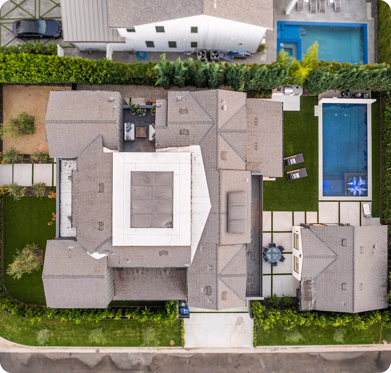
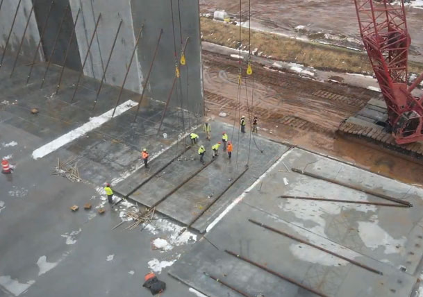
Streamline your construction projects with high-accuracy mapping, LIDAR scanning, and aerial progress monitoring. Our drone solutions provide real-time data for better planning, efficiency, and cost control.
Outdoor
Whether you need property mapping, herd analysis, or terrain visualization, our drone technology helps you manage land with precision, offering data-driven insights for outdoor industries.
Media
Elevate your brand or event coverage with high-quality aerial photography and videography. Whether it’s for marketing, real estate, or documentary filmmaking, our drones deliver cinematic visuals with unparalleled precision.
agriculture Spraying
From drone-powered crop spraying to large-scale property mapping, our advanced UAV technology enhances agricultural efficiency, reduces waste, and maximizes yields with data-driven insights.
construction Mapping
Streamline your construction projects with high-accuracy mapping, LiDAR scanning, and aerial progress monitoring. Our drone solutions provide real-time data for better planning, efficiency, and cost control.
Deer Herding and Analysis
Whether you need property mapping, herd analysis, or terrain visualization, our drone technology helps you manage land with precision, offering data-driven insights for outdoor industries.

Drone Photos and videos
Elevate your brand or event coverage with high-quality aerial photography and videography. Whether it’s for marketing, real estate, or documentary filmmaking, our drones deliver cinematic visuals with unparalleled precision.


why we’re the best at providing Drone data technology solutions
SkyHound delivers cutting-edge drone data solutions tailored to construction, agriculture, outdoor management, and media industries. With advanced technology, precision-driven results, and a commitment to efficiency, we help businesses streamline operations, reduce costs, and gain critical insights from above.
Unmatched Expertise in Restricted Airspace
Operating in DC, Maryland, and Virginia, we specialize in navigating FAA regulations and restricted airspace, ensuring compliant and seamless drone operations.
Precision Crop Spraying & Land Analysis
SkyHound's drone-based spraying and herd analysis help farmers and landowners optimize yields, reduce chemical waste, and improve herd management with cutting-edge aerial insights.
Search & Recovery Solutions with Thermal Imaging
Our thermal drone technology assists in wildlife tracking, deer recovery, and search operations, ensuring rapid, accurate results even in challenging terrain.
Advanced LiDAR & 3D Mapping Capabilities
Our LiDAR and orthomosaic mapping deliver highly accurate topographical data for construction, infrastructure planning, and environmental assessments.
Reliable Data for High-Stakes Projects
From construction site progression tracking to stockpile scans, our drone solutions provide reliable, data-driven decision-making for projects of all sizes.
Industry-Tailored Media & Aerial Videography
With years of experience in cinematic drone capture, we provide high-impact aerial footage for marketing, real estate, and outdoor adventure media.
See How We Helped These Companies Succeed
LiDAR Archaelogical Study
Lorem ipsum dolor sit amet, consectetur adipiscing elit. Suspendisse varius enim in eros elementum tristique. Duis cursus, mi quis viverra ornare, eros dolor interdum nulla, ut commodo diam libero vitae erat.
220K
Deer recoveries completed
175
Acres mapped
90%
Of acres flow for agriculture clients
Featured Case Study title will Go over Here
Lorem ipsum dolor sit amet, consectetur adipiscing elit. Suspendisse varius enim in eros elementum tristique. Duis cursus, mi quis viverra ornare, eros dolor interdum nulla, ut commodo diam libero vitae erat.
100K
Deer recoveries completed
50K
Acres mapped
10K
Of acres flow for agriculture clients
Still Not Sure we’re The Right Choice?
At SkyHound, we redefine aerial data collection with advanced drone technology that delivers faster, more accurate, and cost-effective results. Unlike traditional methods, our approach eliminates inefficiencies, reduces labor costs, and provides real-time insights that help businesses make better decisions.
Traditional Methods

SkyHound Drones Difference

Take Your Business to New Heights with SkyHound
Unlock the power of precision drone data to optimize your operations, cut costs, and gain a competitive edge. Schedule a consultation today and see how SkyHound can elevate your business.